Pompton Lakes Works

  • HOME
  • RESOURCES
  • FAQ
  • SITE HISTORY
  • VAPOR MITIGATION UPDATES
  • POMPTON LAKE PROJECT
  • CONTACT US
    • Home
    • Resources
    • FAQ
    • Site History
    • Vapor Mitigation Updates
    • Pompton Lake Project
    • Contact Us
    Pompton Lake Project Overview

    • Legend:
    • Removal Areas

    Project Overview

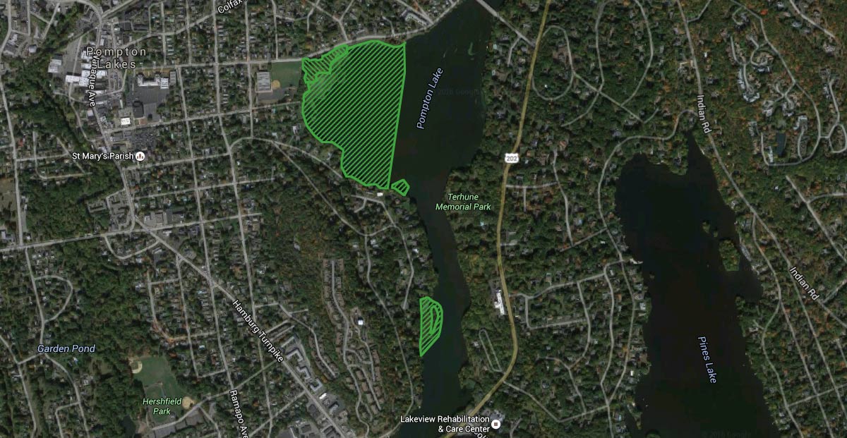
    USEPA issued a modification to the Pompton Lakes Works facility RCRA permit on June 22, 2015 to remove mercury impacted soils and sediment from Pompton Lake. The remedy encompassed four areas consisting of approximately 40 acres. The areas identified in the permit modification included upland soils between Rotary Park and the lake, the lake bottom adjacent to Rotary Park, and the lake bottom at two downstream locations.  A map depicting these areas is provided below.

    A Corrective Measures Implementation (CMI) work plan which describes the means and methods upon which the remedy will be completed was approved by USEPA on April 22, 2016. Field activities associated with the remedy commenced in early June 2016.  Work completed in 2016 consisted of the removal of soils in the Uplands Area and sediments in the Island Area and Lake Area A.  Work completed in 2017 consisted of the removal of sediment from the Delta Area.  Work completed in 2018 consisted of the placement of eco-layer material in the Delta Area and Island Area as well as restoration in these two areas.

    Download Monitor and Removal Area Detail View

    Monitoring Program Data View Archives

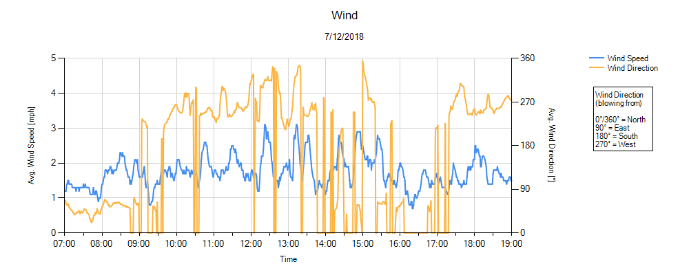
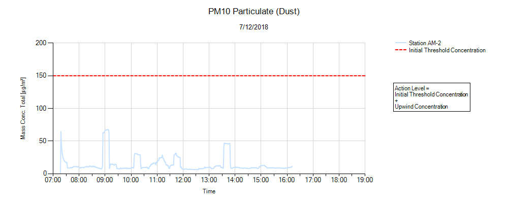
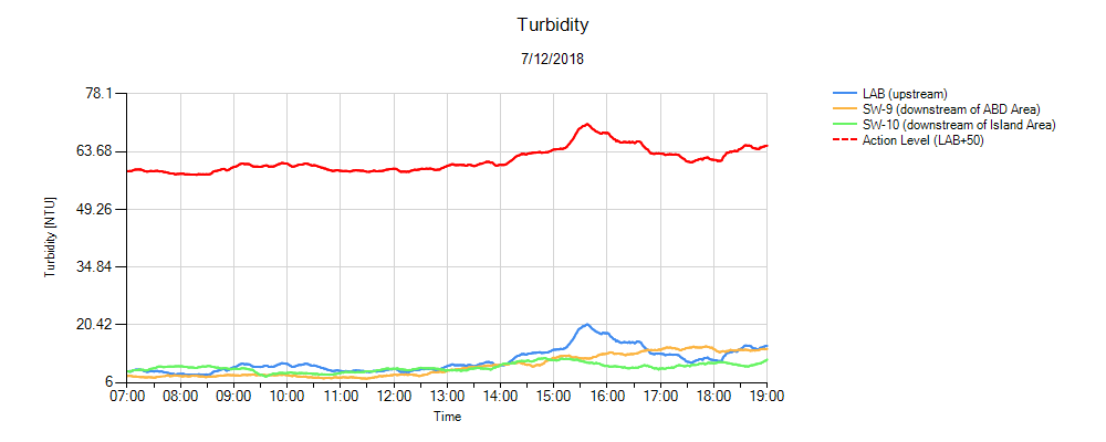
    Environmental monitoring of surface water (turbidity), air (dust and mercury vapor), and noise was conducted in accordance with the CMI work plan during the removal phases of the remediation program.

    Chemours is committed to sharing monitoring data (turbidity, dust, mercury vapor) collected during remedy implementation with the community. The graphs below contain data from the various monitoring locations around the project area.


    1. Wind Monitoring

    Wind Environmental Monitor Graph
    Click Image to Enlarge

    Comments

    Today marks the last day of monitoring the weather for the project.  Work associated with the removal and handling/processing of impacted soil and sediment was completed in 2017.  In accordance with the work plan, no additional monitoring is required.


    2. PM10 Particulate (Dust) Monitoring

    Dust Environmental Monitor Graph
    Click Image to Enlarge

    Comments

    Today marks the last day of dust monitoring for the project.  Work associated with the removal and handling/processing of impacted soil and sediment was completed in 2017.  In accordance with the work plan, no additional monitoring is required.


    3. Mercury Vapor Monitoring

    Mercury Environmental Monitor Graph
    Click Image to Enlarge

    Comments

    Dredging and sediment processing complete – mercury vapor monitoring no longer being conducted.


    4. Turbidity Monitoring

    Turbidity Environmental Monitor Graph
    Click Image to Enlarge

    Comments

    Today marks the last day of turbidity monitoring for the project.  Work associated with the removal and handling/processing of impacted soil and sediment was completed in 2017.  Eco-layer placement in the water is also complete as of this week.  In accordance with the work plan, no additional monitoring is required.


    View Archives


    Archives

    • July 2018
    • June 2018
    • May 2018
    • April 2018
    • March 2018
    • February 2018
    • December 2017
    • November 2017
    • October 2017
    • September 2017
    • August 2017
    • July 2017
    • June 2017
    • April 2017
    • January 2017
    • December 2016
    • November 2016
    • October 2016
    • September 2016
    • August 2016
    • July 2016
    • June 2016
    Copyright 2023 Pompton Lakes Works Remediation Project Information Center. All rights reserved.